One of the most unique things about Region Six is that it is the only region in Guyana that has three towns. As if that wasn’t enough, it is also the only region to include parts of all the four natural regions. Yes, East Berbice-Corentyne is indeed one of a kind. It includes notable landmarks along with the popular 63 beach that is ever so loved by many Guyanese. This article will reveal the lifestyle of the people of Region Six as well as some places to visit.
One of the most unique things about Region Six is that it is the only region in Guyana that has three towns. As if that wasn’t enough, it is also the only region to include parts of all the four natural regions. Yes, East Berbice-Corentyne is indeed one of a kind. It includes notable landmarks along with the popular Number 63 Beach that is ever so loved by many Guyanese. This article will reveal the lifestyle of the people of Region Six as well as some places to visit.
About East Berbice-Corentyne (Region 6)
East Berbice-Corentyne is one of ten regions in Guyana covering the whole of the east of the country. It borders the Atlantic Ocean to the north, Suriname to the east, Brazil to the south and the regions of Mahaica-Berbice (Region 5), Upper Demerara-Berbice (Region 10), Potaro-Siparuni (Region 8) and Upper Takutu-Upper Essequibo (Region 9) to the west. The Corentyne River forms the whole of the eastern border with Suriname, though the southern-most section is disputed territory known as the Tigri Area. The East Berbice-Corentyne Region is the only one to include parts of all the four natural [geographic] regions: Low Coastal Plain, Intermediate Savannah, Hilly and Sandy Clay Area and Forested Highland.
Did You Know? Region Six is the only region with three towns: New Amsterdam, Rose Hall and Corriverton.
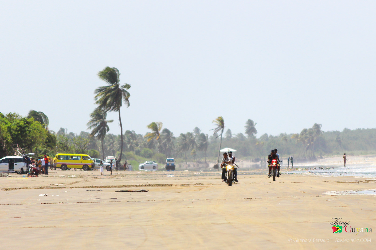
Number 63 Beach
Communities In East-Berbice Corentyne (Region 6)
There are a number of communities in East Berbice-Corentyne; they are:
- Adventure
- Albion
- Alness (Alnes)
- Ankerville – Port Mourant
- Barakara (Barakara Mission)
- Belvedere
- Betsy Ground
- Bloomfield
- Brandwagt-Sari
- Bound Yard – Port Mourant
- Brighton
- Bush Lot (Bush Lot Village)
- Canefield
- Chesney
- Clifton Settlement – Port Mourant
- Corriverton
- Crabwood Creek
- Cumberland
- Dukestown
- East Canje
- Epira (Epira Mission, Espera)
- Eversham Village
- Friendship (Friendship Village, Corentyne)
- Free Yard – Port Mourant
- Fyrish (Fyrish Village)
- Merville – Mohabir (Number 29)
- Gangaram
- Goldspie
- Goed Bananen Land
- Good Hope
- Haswell – Port Mourant
- Hogsty
- Islington
- Java
- Joanna
- Johns Settlement – Port Mourant
- Karaudanawa
- Kumaka
- Lancaster (lancaster Village)
- Leeds
- Letter Kenny
- Lesbeholden
- Limlair
- Liverpool
- Macaw
- Manchester
- Mara
- Mibikuri
- Miss Phoebe North And South- Port Mourant
- Moleson Creek
- New Amsterdam
- New Forest
- New Ground Village
- New Hampshire
- Number Forty-Three
- Number Forty-five
- Number Forty-six
- Number Forty-seven
- Number Fort-Eight
- Number Fifty-nine
- Number Sixty
- Number Sixty-one
- Number Sixty-two
- Number Sixty-three
- Number Sixty-Four
- Number Sixty-six
- Number Sixty-seven
- Number Sixty-eight
- Number Sixty-nine
- Number Seventy
- Number 80
- Nurney
- Orealla (Oreala, Orealla Mission)
- Port Mourant (Port Mourant Village)
- Portuguese Quarters – Port Mourant
- Princetown
- Providence Place
- Reliance
- Rising (Rising Sun)
- Rose Hall
- Rose Hall Village
- Scottsburg
- Skeldon (Skeldon Place)
- Smythfield
- Springlands (Springlands Place)
- Stanleytown
- Tain Settlement – Port Mourant
- Tain Resource – Port Mourant
- Tarlogie (Tarlogie Farm)
- Train Line Dam – Port Mourant
- Ulverston
- Ward Village
- Wel te Vreeden
- West Canje
- Whim
- Yakusari
- Hackstyle
- Williamsburg
Population In East Berbice-Corentyne (Region 6)
Tamil (Madrasi) Indians are the majority in this region. The Government of Guyana has administered four official censuses since the 1980 administrative reforms, in 1980, 1991, 2002 and 2012. Official census records for the population of East Berbice-Corentyne are as follows:
- Year 2012: 109,431
- Year 2002: 123,695
- Year 1991: 142,541
- Year 1980: 152,386
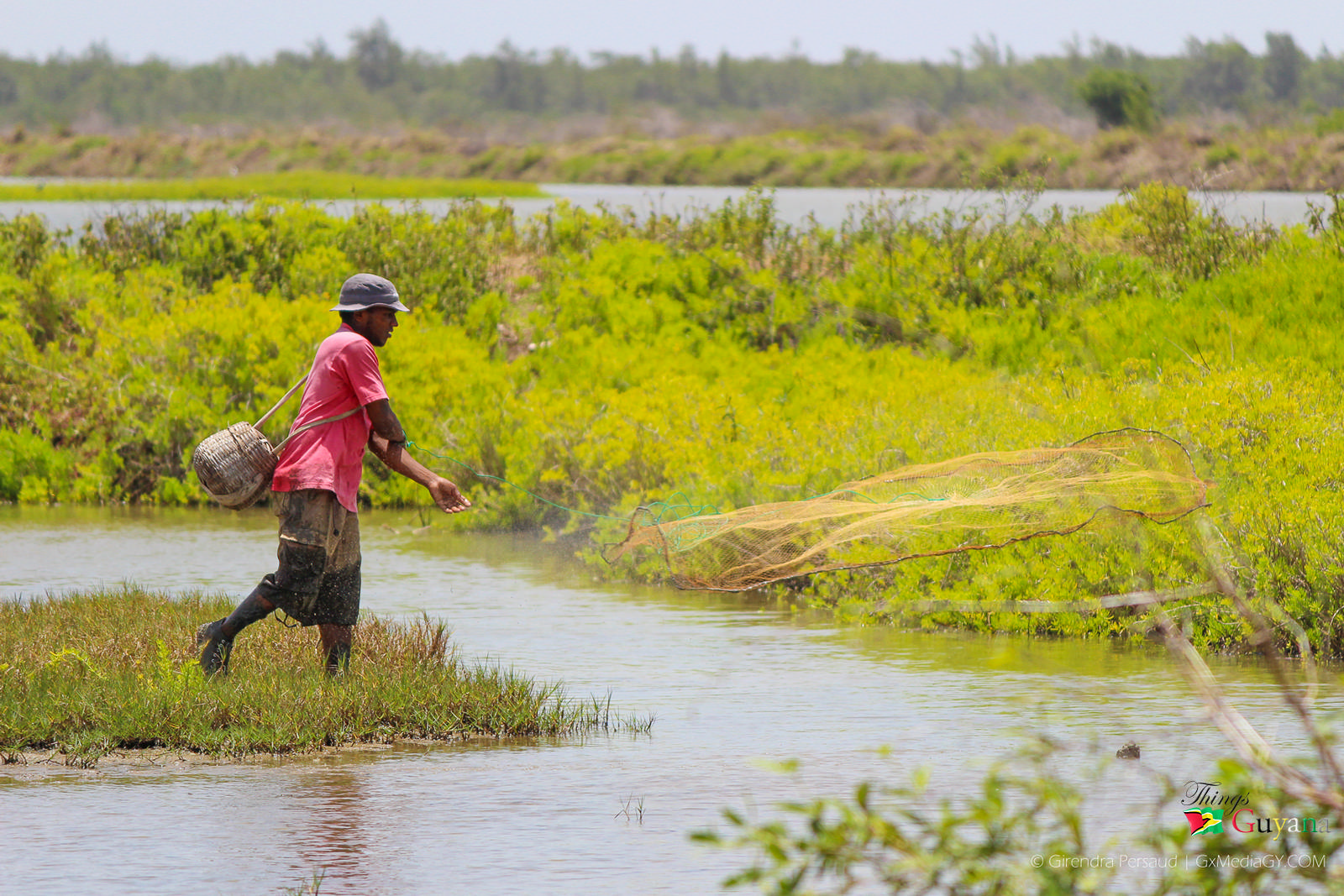
Casting a fish net in Berbice
Lifestyle Of Persons Residing In East Berbice-Corentyne (Region 6)
This region is an important rice-producing, cattle-rearing and sugarcane-producing area but is difficult to drain and irrigate. Because of this, the Torani Canal was dug to join the Berbice River and the Canje Creek. Water flows between the two and provides adequate water for irrigating the land between them. The area of Black Bush Polder, which used to be a large swamp, was established as a land development scheme. The Government of Guyana gave people land for houses and for farming rice and their own kitchen farms. Herds of cattle are reared for beef and dairy on the Intermediate Savannahs. Many of the other resources of the region are not fully exploited. Logging is only conducted on a small scale, although the seasonal forests of this region can yield a variety of timber. Bauxite soil, glass-sand and deposits for making tiles are centered in the hilly sand and clay section of the region. Coconut farming is done on a large scale. Copra (the dried kernel of ripe coconuts) is sold to be made into soap and margarine. Sawmilling is also done privately; sawmills can be found along the banks of the Canje and Berbice rivers.

A Farm House
Places To Visit In East Berbice-Corentyne (Region 6)
- Black Bush Polder (Development Schemes) – This was set up to serve four sections called Polders. The four are: Lesbeholden, Johanna, Yakasary and Mibicuri.
- Orealla – This is an indigenous village where you can experience the local life of the Amerindian people as well as the flora and fauna.
- Ferry Crossing – There is a car ferry across the Corentyne river that connects Guyana to Suriname.
- 63 Beach – This is a beach for the entire family; it is a great place for family time, swimming, picnicking, various sports or just enjoy the water and environment.
- Fort Nassau – This Fort which was declared a national monument in 1999, is located approximately 88 kilometres upstream the Berbice River from New Amsterdam. It was formed on the Eastern bank of the Berbice River in 1627 by Abraham Van Pere, a Dutch merchant, and his colonists.
- Notable Landmarks – The Canje Bridge, the Bandstand, the long stretch of the No. 19 Road, the Mission Chapel Congregational Church, the New Amsterdam Town Hall, the Bush Lot Racing Course, and the old New Amsterdam Hospital are incredible sights to see.

The East Bank of the Berbice River – The Berbice Bridge
East Berbice-Corentyne (Region 6) In Guyana
Truly, the East Berbice-Corentyne Region is the only one to include parts of all the four natural [geographic] regions: Low Coastal Plain, Intermediate Savannah, Hilly, Sandy and Clay Area and Forested Highland. And it is also the only region with three towns: New Amsterdam, Rose Hall and Corriverton. Come with your family to explore this admirable region and enjoy all that it has to offer.
Article References:
- https://guyanatimesgy.com/over-1000-cattle-die-in-black-bush-polder-flood/
- https://newsroom.gy/2016/08/14/forth-nassau-cradle-revolution/
- https://en.wikipedia.org/wiki/East_Berbice-Corentyne
- https://moc.gov.gy/category/region-6/
- https://www.guyanatourism.com/berbice/


1 Comment
Pingback: Beryl Gilroy - The Trailblazing Educator, and Ethno-Psychotherapist